Social Explorer: Current and historical demographic data
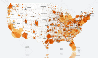
 Social Explorer provides quick and easy access to current and historical demographic data. Easy-to-use online tools help users create custom maps and reports to visualize, explore and understand the patterns behind the numbers. The latest version offers new ways to explore and present data from 1790 to the present, from U.S. neighborhoods to across the globe. Users can access more than 220 years of census data with tens of thousands of maps, hundreds of reports, over 400,000 variables and 40 billion data elements.
The core data library includes U.S. Census data from 1790 to 2010 and American Community Survey data from 2005 to 2014. Users can examine this wealth of demographic information at the national, state, county, census tract, metropolitan statistical area (MSA) and block group geographic levels (where available).
Specialized U.S. data resources include the FBI Uniform Crime Report data (2010 and 2012), American election results (1912 to 2014), Religious Congregations and Membership Study (1980 to 2010), Vulcan Project carbon emissions data (2002), and County Health Rankings and Roadmaps Program data (2010 to 2016).
International data resources include the United Kingdom Census (2011), Canadian Census (2011), Eurostat (1990, 2000, 2010 to 2013), World Development Indicators (2013), and Irish religion and population data (1911 to 2001).
Users can create detailed data reports with the Reporting Tools. Export one or thousands of variables and geographies quickly and easily. Excel, CSV, and other file formatting shortcuts allow you to work with data in a variety of software programs for further analysis.
Users are encouraged to create an account so that they are able to save their work and access it for later use.
by Patricia Sobczak, business and public affairs collections librarian
Categories Planning and Urban Development, Political Science, Public Affairs, Social Sciences, Wilder School